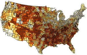
Create Maps of Fatal Injuries through the New WISQARS™ Fatal Injury Mapping Module
The National Center for Injury Prevention and Control (NCIPC) is pleased to release a new WISQARSTM (Web-based Injury Statistics Query and Reporting System) Fatal Injury Mapping Module. The module allows users to produce customized, color-coded maps depicting injury-related death rates throughout the United States. WISQARSTM is a leading source of statistics for injury and injury-related death in the United States. It’s an interactive, Web-based query system that provides data on injury-related deaths, violent deaths, and nonfatal injuries.

"The WISQARS Mapping Module is quickly becoming an indispensable tool in our injury prevention work, including in the area of motor vehicle safety. Through these maps, we can rapidly identify geographic patterns in injury death rates. As a result, we are able to tailor our interventions to the regions in greatest need, even down to the county-level. Being able to compare injury death rates with such specificity and ease will be a real asset as we continue our work to keep people healthy and safe on the road—every day.
—Dr. Grant Baldwin, PhD, MPH, Director of the Division of Unintentional Injury Prevention
The new Fatal Injury Mapping Module has many useful features, including that it:
- Defines injury-related deaths in terms of intent (e.g., unintentional, homicide, suicide) and mechanism of injury (e.g., motor-vehicle traffic, fall, fire or burn, poisoning, cut or pierce).
- Generates county-level maps using 7 years of data, the amount needed to produce reliable county-level injury-related death rates.
- Helps users compare injury rates across specified geographic areas and monitor fatal injuries and their associated burden in the United States.
- Provides annualized estimates of total lifetime medical and work-loss costs resulting from injury-related deaths based on 2005 costs that are provided for counties within individual states.
- Shows the distribution of injury-related death rates nationally, regionally, and by individual states and counties.
Insights gained from maps generated by the WISQARSTM Fatal Mapping Module also will help raise awareness of injuries as a leading cause of death for various populations. Public health officials can use these maps to aid in program planning and evaluation activities, reporters can create maps for visual complements to injury-related news stories, and policy makers when developing injury-prevention programs and legislation can reference these maps to better illustrate injury-related death rate patterns in their jurisdictions.
The new Fatal Injury Mapping Module and more information about WISQARSTM is available at: www.cdc.gov/injury/wisqars.
- Page last reviewed: December 24, 2015
- Page last updated: December 24, 2015
- Content source:
- Centers for Disease Control and Prevention, National Center for Injury Prevention and Control


 ShareCompartir